Header


Phoebettmh Travel

Travel to anywhere, Travel Point, Travel tour list, Start Nowwww...

(Ireland) –10 things to do and see near the Cliffs of Moher

The Cliffs of Moher (Irish: Aillte an Mhothair, lit. cliffs of the ruin, also known as the Cliffs of Mohair) are located in the parish of Liscannor at the south-western edge of the Burren area near Doolin, which is located in County Clare, Ireland.

(Ireland) –Cliffs of Moher
 
The cliffs rise 120 meters (390 ft) above the Atlantic Ocean at Hag's Head (Irish: Ceann na Cailleach), and reach their maximum height of 214 meters (702 ft) just north of O'Brien's Tower, eight kilometres away. The views from the cliffs attract close to one million visitors per year. On a clear day, the Aran Islands are visible in Galway Bay, as are the valleys and hills of Connemara.

(Ireland) –Cliffs of Moher
 O'Brien's Tower is a round stone tower at the approximate midpoint of the cliffs. It was built by Sir Cornelius O'Brien, a descendant of Ireland's High King Brian Boru, in order to impress female visitors. From atop that watchtower, visitors can view the Aran Islands and Galway Bay, the Maum Turk Mountains and the Twelve Pins to the north in Connemara, and Loop Head to the south.

The Cliffs of Moher rank as one of the most popular tourist destinations in Ireland and topped the list of attractions in 2006 by drawing almost one million visitors. 10 things to do and see near the Cliffs of Moher:

(Ireland) –Cliffs of Moher
 
1. Atlantis take a bracing walk along the cliff tops, try and spot or hear the fabled bells of Irelands very own lost city of Atlantis.

2. St Brigid’s well about 2 miles south of the cliffs on the right beside the O'Brien monument is a very famous holy well, and a revered place of pilgrimage every spring on Feb 1st.

(Ireland) - Cliffs of Moher Cruise
3. Vaughans Restaurant stop for something to eat in the little seaside village of Liscannor, superb food served all day in a traditional pub atmosphere, excellent pints & deserts!

4. Lahinch Seaworld great rainy day alternative, Irelands biggest aquariam, indoor pool and leisure centre.

5. Atlantic Hotel a truly elegant throw back to the glamourous days of seaside holidays, fine dining, white linen tablecloths, silver candlesticks, need I say more?

6. Lahinch Surf School run by the guys who made the video, learn how to surf like a pro! all ages, all stages, be bold, be brave....be careful!

7. Cliffs of Moher Cruise take a scenic boat tour along the base of the cliffs, out of Doolin to see the puffin colonies, this is really great and fun to do with plenty of excellent photo opportunities for the snap happy.

8. O'Connors Pub in Doolin, on the go since 1832, famous throughout Ireland and even the world for traditional Irish music sessions or seisuins as they are known as gaelige. Their beef in Guinness stew is not half bad either?

9. Doolin Cave see the largest stalactite in the northern hemisphere, great Indiana Jones style adventure. have been for a ride on the Happy Hooker.

10. Ballinalackin Castle Hotel have a posh dinner, or stay in this superb country house hotel with the best breakfast sausages in Ireland.

Food, Hotel and more

1. Cullinans Seafood Restaurant fast making a name for themselves as one of the best fish restaurants in the West!

2. Aille River Hostel Awarded 2nd Best Hostel in Ireland 2009

3. Irish Music Shop a treasure trove for music lovers with rare sheet music as well as instruments.

(Ireland) - Doolin Cave
4. Doolin Jam Company drop in and treat yourself to the best homemade jams in Ireland which come in tempting flavours like champagne&raspberry, port&blackcurrant, whiskey marmalade...

5. Doolin Hotel contemporary cool in a rural landscape.

6. Lehinch Golf Links reputedly another one of Tiger Woods favourites

7. Orbital Winds Kite surfing school for the ultimate adrenalin rush.

8. The Lahinch Bookshop enjoys the rare & delicious treat of browsing through real books not an online catalogue in this well stocked bookshop.

9. Burren Smokehouse helps yourself to free samples of premium oak smoked salmon & other artisan food goodies in Lisdoonvarna.

10. Doolin Cave or Poll an Iolain, saving the best till last! This is the ‘real deal’ a supervised geological experience

(Wiki, Irelands Hidden Gems)
Read more

(Poland) – Welcome to Masurian Lake District

The Masurian Lake District or Masurian Lakeland (Polish: Pojezierze Mazurskie; German: Masurische Seenplatte) is a lake district in northeastern Poland within the geographical region of Masuria. It contains more than 2,000 lakes. The district had been elected as one of the 28 finalists of the New7Wonders of Nature.

(Poland) – Masurian Lake District
 
The Lakeland extends roughly 290 km (180 mi) eastwards from the lower Vistula River to the Poland-Lithuania border, and occupies an area of roughly 52,000 square kilometres (20,000 sq mi). Administratively, the Lake District lies within the Warmian-Masurian Voivodeship. Small parts of the district lie within the Masovian and Podlaskie Voivodeships.

(Poland) – Masurian Lake District
 
The lakes are well connected by rivers and canals, forming an extensive system of waterways. The 18th-century Masurian Canal links this system to the Baltic Sea. The whole area is a prime tourist destination, frequented by boating enthusiasts, canoeists, anglers, hikers, bikers and nature-lovers. It is one of the most famous lake districts in Central Europe and a popular vacation spot, with the highest number of visitors every year.

How to get there
The Masurian Lakeland can be reached by air, train, bus, or car.
- The nearby international airports are in Warsaw, Gdańsk, and Vilnius.
- The main transport hub in the region is the town of Ełk. There are trains to Masuria from Warsaw, Gdańsk and Vilnius, and buses from many Polish cities.
- A boat service connects some central towns in the region. Biking and boating are popular ways to get around.

(Poland) – Masurian Lake District

 Hotels can be found in close proximity to the Great Masurian Lakes, in towns of Giżycko, Mikołajki and Ełk among others. There are also guesthouses and campsites in surrounding villages.

Sights and Activities
Masuria is famous for its lakes and forests, offering a wide range of outdoor activities from sailing to kayaking and swimming. The region includes the largest lake in Poland called Śniardwy. The resort towns include the most popular Giżycko and Mikołajki, Węgorzewo, Ryn, Pisz and Iława. Giżycko is located on the shore of Lake Niegocin. It has an ancient fortress, historic church, bridges, and passenger boats to the towns of Węgorzewo, Mikołajki and Ruciane-Nida.

(Poland) - Masurian Lake District - Lake Śniardwy
 
The town of Mikołajki is a popular tourism center. In addition to lakes, the Masurian region also has many rivers used for fly fishing, and forest areas that offer many trails for trekking and biking. There is also a variety of wildlife, edible berries and mushrooms, and large protected areas, including the Masurian Landscape Park that includes 11 nature reserves such as the Łuknajno Lake that is a UNESCO Biosphere Reserve, or the Białowieża Forest with a breeding station for European Bisons.
(Wiki)
Read more

(Germany) - Black Forest (Schwarzwald) – Home of the cuckoo clock

The Black Forest (Schwarzwald) is one of Germany’s oldest and most popular holiday regions and even people who aren’t familiar with the region know that it’s the home of the cuckoo clock, have enjoyed its famous Black Forest cake and heard of some old myths and legends of sorcerers, witches and werewolves that supposedly lurk in the dark forests.

(Germany) - Black Forest (Schwarzwald)
 
The Black Forest is a wooded mountain region in the German state of Baden-Württemberg in the southwestern part of Germany. This region of about 200 kms long and 60 kms wide of rolling hills and lush valleys is bordered by France on its west, Switzerland on its south, the Swabian Alb and Lake Constance in the east and the Kraichgau region in the north.  Germans and other Europeans know it well as for over two decades, the German television medical series Die Schwarzwaldklinik (Black Forest Clinic) brought images of the Black Forest into the living rooms of millions of viewers in over 40 countries.

Famous for its Good Food, Wellness Spas and Walking Holidays

The Black Forest certainly has a lot more to offer visitors than Black Forest cake, cuckoo clocks and ham. The region enjoys 28 million overnight stays per annum and people come here to enjoy its good food, the wellness spas, relaxation, hiking or driving holidays, or to take a walk in the Black Forest.

(Germany) Europa Park Rust
The Schwarzwald is home to a number of internationally renowned towns and places of interest, such as Calw, the birthplace of the author Herman Hesse, the UNESCO World Heritage listed Maulbronn Monastery Complex and Baden-Baden, famous for its spa and casino. As well as the charming university towns such as Tübingen and Freiburg you’ll also come across fairy-tale villages.

(Germany) Freiburg
(Germany) Freiburg
 
The Schwarzwald oozes with health and this region boasts the highest concentration of spas, health resorts and hotels with beauty and fitness facilities in Germany.  And for the young ones, Germany’s biggest theme park, the Europa-Park Rust is also in the Black Forest.

Black Forest Cake
Black Forest Cake
Train trips and driving holidays are a popular way to see the best of the area. Scenic routes in the northern section include the Black Forest Spa Route and the Black Forest Valley Route whereas in the south-west, near Freiburg is the Black Forest Panorama Route.

A Skiing Tradition

The The Black Forest was the birthplace of skiing in central Europe, with the first ski club being founded at the Feldberg Mountain.  It was also here that the first wooden skis were produced and the first ski lift built. Today, the Feldberg region is one of the largest ski resorts outside of the Alps. The Feldberg Mountain rises to a height of 1,493 metres and in winter its powdery pistes are a great attraction to skiers.

(Germany) -Tubingen
(Germany) -Tubingen
Visiting the Schwarzwald one also gets to experience its rich culture and traditions, which people here believe in preserving. Depending on the occasion, you may see women dressed in traditional costumes and most certainly you’ll still see women in the famous “Bollenhut” hats with their distinctive pompoms. Girls and unmarried women wear hats with the bright red pompoms whilst the married women have black pompoms on their hats.

And then, there’s the good food – apparently about 10% of Germany’s top 100 chefs are working in the kitchens in the Black Forest.

(travelsignposts)
Read more

(Lebanon) - A full day tour to the Jeita Grotto

Jeita Grotto is a compound of crystallized caves in Lebanon located 20 km north of Beirut in the Valley of Nahr al-Kalb (Dog River). This cave has several name changes the Grottoes Nahr al-Kalb, then known as Djaita, Jehita, and finally Jeita. Naher el Kalb is the name of the river that flows through the caves, while Jeita, which means “roaring water” in Aramaic, is the city where the cave entrance is located. The transition from Nahr al-Kalb Grottoes ke Jeita Grottoes occurred in 1927 many newspapers used the last name.

(Lebanon) - A full day tour to the Jeita Grotto
  This grotto is made up of two limestone caves, upper galleries and a lower cave through which a 6230 m long river runs. Geologically, the caves provide a tunnel or escape route for the underground river. In this cave and galleries, the action of water in the limestone has created cathedral-like vaults full of various sizes, colors and shapes of stalactites and stalagmites, majestic curtains and fantastic rock formations. The total length of the cave is more than 9000 m and there is one among the biggest stalactites in the world hanging 8,20 m. The grotto accommodates a huge hall with a distance of 108 m from the ceiling till the water level.

(Lebanon) - A full day tour to the Jeita Grotto

 The remains of the ancient foundry were found in a small cave near the Nahr al-Kalb River, indicating that the cave was used in antiquity to produce swords.

(Lebanon) - A full day tour to the Jeita Grotto

 (Wiki, Hangouto)
Read more

Azerbaijan is home to nearly 400 Mud Volcanoes

The term mud volcano or mud dome is used to refer to formations created by geo-excreted liquids and gases, although there are several different processes which may cause such activity. It is estimated that 300 of the planet's estimated 700 mud volcanoes are found in Gobustan, Azerbaijan and the Caspian Sea. In Azerbaijan, eruptions are driven from a deep mud reservoir which is connected to the surface even during dormant periods, when seeping water still shows a deep origin. Seeps have temperatures up to 2–3 °C above the ambient temperature. In 2001, one mud volcano 15 kilometers from Baku made world headlines when it suddenly started spewing flames 15 m high.

(Azerbaijan) is home to nearly 400 Mud Volcanoes
Azerbaijan is home to nearly 400 Mud Volcanoes
 
Azeri mud volcano flares

In the Spring of 2001, volcanic activity under the Caspian Sea off the Azeri coast created a whole new island. In October 2001there was an impressive volcanic eruption in Azerbaijan at Lokbatan, but there were no casualties or evacuation warnings.

But Azerbaijan does not have a single active volcano, at least not in the usual sense of the word. What Azerbaijan does have is mud volcanoes - hundreds of them. Mud volcanoes are the little-known relatives of the more common magmatic variety. They do erupt occasionally with spectacular results, but are generally not considered to be dangerous.

Tourist itinerary

Azerbaijan and the Caspian Sea are home to nearly four hundred mud volcanoes - more than half the total throughout the world. Tourists often look for them around Alat, Gobustan, Salyan and other locations.
Mud volcanoes come in a variety of shapes and sizes, but those most common in Azerbaijan have several small cones, or vents, up to about four metres in height (13 feet), sometimes topping a hill ofseveral hundred metres.

These small cones emit cold mud, water and gas almost continually - an amazing and even beautiful sight, which has become part of the tourist itinerary for foreigners visiting Azerbaijan.

But sometimes even mud volcanoes have their day.

Huge flames, tonnes of mud

Every twenty years or so, a mud volcano may explode with great force, shooting flames hundreds of metres into the sky, and depositing tonnes of mud on the surrounding area.

This was the kind of eruption that witnesses described seeing on a hillside 15 kilometres (nine miles) outside the Azerbaijani capital Baku on Thursday morning (25/10/2001).

(Azerbaijan) is home to nearly 400 Mud Volcanoes
Azerbaijan is home to nearly 400 Mud Volcanoes
 
"There was a big explosion, and a huge flame started coming from the hillside," said one witness. "It looked as though an animal was trying to get out of the ground.

"The flame was unbelievably big, about three hundred metres high. It was surrounded by dense, black smoke, and lots of mud was being thrown into the air.

"The biggest flames burned for about five minutes.Then there was another huge explosion, and then they calmed down to about 10 or 20 metres (32 or 65 feet) high."

The flames could easily be seen from 15 kilometres away on the day of the explosion, and were still burning, although at a lower level, three days later.

Land of fire

Mud volcanoes are one of the visible signs of the presence of oil and gas reserves under the land and sea in the Caspian region. Gas seeps are a related phenomenon.

These occur when a pocket of gas under the ground finds a passage to the surface. One gas seep burns continually on a hillside near Baku, ignored by the sheep but sometimes visited by curious tourists.

It is an unearthly sight, especially at dusk, and it is easy to understand how these fires that never appear to burn out became objects of worship.

The appearance of the Zoroastrian religion in Azerbaijan almost 2,000 years ago is closely connected with these geological phenomena, and, according to one theory, the name "Azerbaijan" itself was derived from the word for "fire" in Persian.

Geologists agree on some aspects of the formation and activities of mud volcanoes. They are formed when mud and sand up to several kilometres beneath the Earth's surface are squeezed upwards by compressive forces and expelled.

(Azerbaijan) is home to nearly 400 Mud Volcanoes
Azerbaijan is home to nearly 400 Mud Volcanoes

 The origins of the volcanoes are disputed. Mud volcanoes are often formed in areas of weakness in the Earth's crust, along fault lines, and are associated with geologically young sedimentary deposits, the presence of organic gas from hydrocarbon deposits, and overlying pressure which forces this gas to the surface.

But when it comes to accounting for the differences between mud volcanoes, their varying shapes and sizes, the gases they emit and their unpredictable behaviour, there is little agreement.

Geologists describe mud volcanoes as "capricious", and are still arguing about exactly how they are formed. Some believe they are created during the sedimentary process itself, while others argue that different processes are also involved, for example, seismic activity.

To the non-geologist, the explanations can seem, well, as clear as mud. But the arguments about their origins only add to the aura of mystery that surrounds these unusual and enigmatic phenomena.

(Wiki, Azerbaijan 24)
Read more

(Venezuela) - 7 Most Interesting Angel Falls Facts

Angel Falls (Spanish: Salto Ángel; Pemon language: Kerepakupai Vená, meaning "waterfall of the deepest place", or Parakupá Vená, meaning "the fall from the highest point") is a waterfall in Venezuela.

(Venezuela) - 7 Most Interesting Angel Falls Facts
 
It is the world's highest waterfall, with a height of 979 m (3,212 ft) and a plunge of 807 m (2,648 ft). The waterfall drops over the edge of the Auyantepui mountain in the Canaima National Park (Spanish: Parque Nacional Canaima), a UNESCO World Heritage site in the Gran Sabana region of Bolívar State. The height figure 979 m (3,212 ft) mostly consists of the main plunge but also includes about 400 m (0.25 mi) of sloped cascades and rapids below the drop and a 30 m (98 ft) high plunge downstream of the talus rapids.

(Venezuela) - 7 Most Interesting Angel Falls Facts
1. One of the most interesting Angel Falls facts is how these falls were discovered. The falls received their name because of an American bush pilot who was named Jimmy Angel. Angel crashed near the top of the falls in the year 1937, and then alerted the world to what he had found. This is one of the top Venezuela vacation spots, and an experience that no visitor should miss.

(Venezuela) - 7 Most Interesting Angel Falls Facts
 
2. There are three ways that you can explore the Angel Falls location. You can hike the falls on foot, but if this is the case be prepared for a hard climb. This allows you to see everything and enjoy all of the scenic vistas. The falls can also be toured by boat, if you do not want to make the climb, or you can take a helicopter tour and see all of the beauty from the air instead.

(Venezuela) - 7 Most Interesting Angel Falls Facts
 
3. One of the interesting Angel Falls facts is the sheer height of the falls. These falls reach more than twenty six hundred feet up, and they are roughly fifteen times as high as Niagara Falls. The longest continuous drop in the falls is over eight hundred meters.

(Venezuela) - 7 Most Interesting Angel Falls Facts
 
4. Angel Falls is located inside the Canaima National Park Venezuela, a park known for exquisite beauty throughout. While the falls may be the most spectacular sight found in the park, it is the most popular and attracts visitors from all around the world.

(Venezuela) - 7 Most Interesting Angel Falls Facts
 
5. Angel Falls facts includes the fact that this waterfall has a bottom base of one hundred and fifty meters. It is possible to take an arranged guided tour, and to make it from the bottom of the falls to the top can take days or even weeks.

(Venezuela) - 7 Most Interesting Angel Falls Facts
 
6. Angel Falls may also go by two other local names, which are Big River Falls and Tulume Bena. With the number of cheap flights to Caracas, this attraction receives thousands of visitors each month. The water of the falls has a silvery sheen to it, which makes it appear to shimmer at times.

7. One of the Angel Falls facts which is interesting is that during the rainy season the falls may divide into two separate waterfalls. When the water level is high it is possible to feel the spray from these falls up to a mile away.

(Wiki and Travel AdVisor Tips)
Read more

(Israel, Jordan, Palestine) – Dead Sea Attractions

The Dead (Hebrew: ים המלח, Hebrew transliteration:Yam HaMelach; Arabic: البحر الميت, Arabic transliteration: al-Bahir al-Mayyit), borders Israel, the West Bank and Jordan.

(Israel, Jordan, Palestine) – Dead Sea Attractions
The Dead Sea is the saltiest lake in the world. It is called "dead" because the high salinity prevents any fish or other visible aquatic organism to live in its water. The high density of the water also causes a curious phenomenon: it is impossible for a bather to sink. Its surface is the lowest point on Earth, at an elevation of 417 below sea level.

(Israel, Jordan, Palestine) – Dead Sea Attractions

(Israel, Jordan, Palestine) – Dead Sea Attractions
 
There are several nearby attractions that are worth attention:

Israel and the West Bank
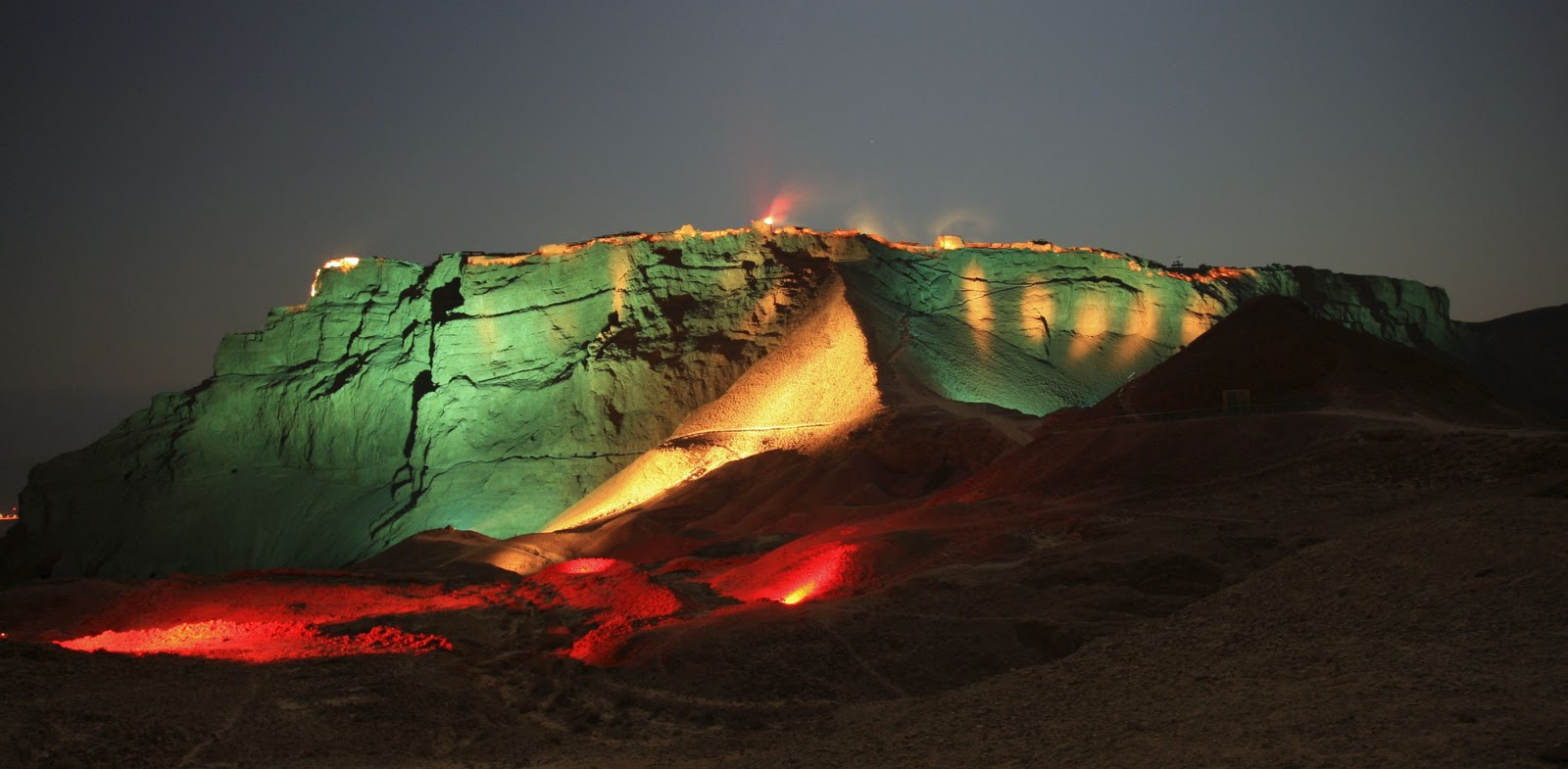
Masada - Mountaintop Fortress, Masada National Park is 18 km south of Ein Gedi, or 12 km from Ein Bokek to the cable train on the east.  Masada is a mountaintop fortress which King Herod transformed in 35 BC into a 3 tiered winter home. The siege of Masada has become in Israel a popular story of heroic resolve, with some accounts reporting that the defenders committed mass suicide instead of surrending. Masada is a UNESCO Word Heritage Site.

Dead Sea - Masada - Mountaintop Fortress
Masada Sound and Spectacular Light Show recounts the dramatic history of Masada with special pyrotechnic effects. Spectators sit in a natural amphitheater on the west side of the mountain, reachable only via Arad, 20km away.

Dead Sea - Masada Sound and Spectacular Light Show
 
Ein Gedi Oasis and Kibbutz.  Ein Gedi is a real oasis with lush vegetation, nestled between two streams, amidst the arid landscape.

Dead Sea - Ein Gedi
Dead Sea - Ein Gedi

Ein Gedi Nature Reserve is situated near the Kibbutz, visitors have access to the adjacent nature reserve for viewing bird sanctuaries and wildlife of the desert, including the Nubian ibex. Hikers have the choice of following two riverbeds and can follow trails past waterfalls, springs, caves, canyons and an early Bronze Age temple.

Dead Sea -  Ein Gedi Nature Reserve
Dead Sea -  Ein Gedi Nature Reserve
Qumran - The Dead Sea Scrolls, Qumran National Park is off of Route 90 near Kibbutz Kalia, north of the Dead Sea. The park is about a 40-minute drive from Jerusalem in the West Bank. The ancient caves and settlement at Qumran on the northern shores of the Dead Sea where the oldest biblical documents ever found trace the history and daily lives of the mystical Essenes, a Jewish sect that fled Jerusalem 2000 years ago.

Dead Sea - Qumran
Dead Sea - Qumran
Jordan

Historic Mount Nebo provides a panorama of the Holy Land, and to the north, a more limited one of the Jordan River valley. The excavated remains of a church and a monument commemorating the biblical story of Moses and the bronze serpent stand atop the mountain. Mount Nebo is a short 15 minute drive from the Dead Sea.

The nearby town of Madaba known as the 'City of Mosaics' is famous for its Byzantine and Umayyad mosaics, especially a large Byzantine-era mosaic map of Palestine and the Nile delta at St. George Church.

The Baptism Site (Bethany Beyond the Jordan) at the Jordan River, the location archaeologists are claiming is the baptism site of Jesus by John the Baptist, is a short 10 minute drive from the Dead Sea resort area.  Buses transport visitors down to the river basin, and guided tours include visits to a Jordan River overlook, the excavated remains of the Baptismal Site, John the Baptist Church, and down to the River bank.

The Dead Sea Panoramaic Complex/Dead Sea Museum is a new complex of regional museum about the Dead Sea, panorama lookout, restaurant and conference hall on a steep cliff high above the Dead Sea near Hammamet Ma'in it is accessible from both the Dead Sea and Madaba by car, however it is difficult to reach by public transport. The museum is run by the Royal Society for the Conservation of Nature, and has some fascinating information about the geology, ecology (animal and plant), archaeology, history and industry of the Dead Sea and surrounding area.It has also information about the environmental problem concerning the Dead Sea, such as decreasing of the Dead Sea water level and sinkhole in the Dead Sea coast. As the name suggests it has a magnificent view of the Dead Sea and the hills beyond it. Watching the sunset from here is a wonderful experience.

The Mujib Reserve of Wadi Mujib is the lowest nature reserve in the world, located in the mountainous landscape to the east of the Dead Sea, approximately 90km south of Amman. The 220 square kilometers reserve was created in 1987 by the Royal Society for the Conservation of Nature and is regionally and internationally important, particularly for the bird life that the reserve supports. The Mujib valley is being developed for adventure tourism, and a number of facilities have been established including a Visitors' Centre and a beach area on the Dead Sea. Experiencing Jordan’s Grand Canyon involves swimming, jumping, abseiling and floating. Its red walls are filled with running water that plunges through a 15 m waterfall.

Hammamat Ma'in is a remarkable series of natural hot springs and waterfalls, some of which have been channeled into pools and baths. A spa resort is located in the vicinity of the waterfalls.

Lot's cave is found on the site of the remains of an old church. The cave is believed to the the one Lot took refuge in with his two daughters when God according to the Bible destroyed Sodom and Gomorrah. The cave and part of the church ruins are fenced off.

Jordan - Lot's cave
Jordan - Lot's cave
(Wiki and Terragalleria)
Read more

(Canada) – Top things to do in Bay of Fundy

Located off the northern coast of Maine and extending into Canada between New Brunswick and Nova Scotia, the natural phenomenon known as the Bay of Fundy is a 270 km (170 mile) long ocean bay that’s home to the world’s highest tides (54 feet/16m). The Bay of Fundy has a diverse ecosystem and a marine biodiversity comparable to the Amazon Rainforest. Its waters are populated with up to 12 species of whales, an abundance of dolphins, porpoises, fish, seals, seabirds and more.

(Canada) – Top things to do in Bay of Fundy
 
Every day, twice a day 110 billion tonnes of seawater rush into the Bay creating phenomena that can only be experienced to be appreciated. Tides are crucial to this ecosystem and are highly respected by everyone who has seen their effect.  The tide waits for no-one, and life along the Bay is dictated by the ebb and flow of water. 

Below are top things to do around the Bay of Fundy:
1. Whale Watch in the Bay of Fundy
Look for the endangered North Atlantic Right Whale and 6 other species that frequent the Bay of Fundy. Many different whales can be found in the Bay of Fundy in the summer, as it is an abundant feeding ground. Minke whales are plentiful.  You can also find humpbacks, fin whales, and the occasional blue whale.  There are also seals and many types of sea birds in the Bay.

(Canada) - Whale Watch in the Bay of Fundy
2. Walk on the ocean floor

(Canada) - Bay of Fundy - Walk on the ocean floor
 
Walk on the ocean floor and explore the tidal pools where the highest tides in the world have been recorded. Although many places claim to have the highest tides in the world, tides at Burntcoat Head are actually the highest, averaging 55.8', with the highest being set during the 1869 Saxby Gale at 70.9'

(Canada) - Bay of Fundy - Walk on the ocean floor
Visit Hopewell Rocks, located on the New Brunswick side of the Bay of Fundy. At low tide, explore quiet coves with flowerpot-shaped rock formations bearing such curious names as 'Mother-in-Law', 'ET' and 'Lover's Arch'.

(Canada) - Bay of Fundy - Walk on the ocean floor
3. Cape d’Or
With rugged red-colored vertical cliffs on either side and sparkling water stretching out as far as the eye can see Cape d'Or bears testimony to the awesome power of nature.  It has the distinction of being the only place in the world where three tides converge, meeting simultaneously to create violent riptides-a phenomenon known as the Dory Rips. The lookout platform affords views of Cape Split and Ile Haute Island.

(Canada) - Bay of Fundy - Cape D'Or Lighthouse
4. Tidal Bore Rafting
At first, the Shubenacadie River seems like a very lazy river. Situated amid 200-foot-high gypsum cliffs, it starts out as a relaxing paddle past mudflats and sandbars until you reach the mouth of the river, where the tides from the Bay of Fundy come rushing in. Suddenly, you're white-water rafting on the world's highest tides, which travel inland at roughly 50 km an hour and stir up sixteen-foot waves.

(Canada) - Bay of Fundy - Tidal Bore Rafting
5. Hall’s Harbour
Hall's Harbour is a fishing port that works to the ever changing rhythm of the 40 foot Fundy tides. Snugly settled in its picturesque cove, and guarded on each side by tall basalt cliffs, the harbour's inner basin fills twice a day to the top of the towering wharves. Six hours later the water recedes far out into the Bay of Fundy leaving the colourful fleet of vessels dry on the harbour floor.  Beach comb for treasures and watch the landscape change as the tide comes and goes.

(Canada) - Bay of Fundy - Hall’s Harbour
(Wiki and  Bay of Fundy Fun Tours)
Read more

(New Zealand) – Visiting Milford Sound

Milford Sound, located in the southwest of New Zealand’s South Island, is located within the Fiordland National Park. It runs 15 km inland from the Tasman Sea and is surrounded by sheer rock faces that rise 1200 m or more on either side. Among its most striking features are Mitre Peak, rising 1,692 m above the sound, the Elephant at 1,517 m and resembling an elephant’s's head, and Lion Mountain, 1,302 m, in the shape of a crouching lion. Lush rain forests cling precariously to these cliffs, while seals, penguins and dolphins populate the water.

(New Zealand) – Visiting Milford Sound
 The beauty of this landscape draws thousands of visitors each day, with between 550,000 and 1 million visitors in total per year. This makes the sound one of New Zealand's most-visited tourist spots, and also the most famous New Zealand tourist destination, even with its remote location and the long journey from the nearest population centre. Almost all tourists going to the sound also take one of the boat tours which usually last between 1–2 hours. They are offered by several companies, departing from the Milford Sound Visitors' Centre. There is also the option of extended overnight cruises on Milford Sound.

Tramping, canoeing and some other water sports are also possible. A small number of companies also provide overnight boat trips. There is otherwise only limited accommodation at the Sound, and only a very small percentage of tourists stay more than the day.

(New Zealand) - Milford Sound Map


An underwater tourist observatory found in one of the bays of the sound provides viewing of black coral, usually only found in much deeper waters. A dark surface layer of fresh water, stained by tannins from the surrounding forest, allows the corals to grow close to the surface here.

In rainy and stormy days tourists can admire the play of the wind with the numerous waterfalls in Milford Sound. When meeting the cliff face the powerful wind often goes upward and waterfalls with a vertical drop get caught by wind, causing the water to go upwards.

Things to do in Milford Sound
Milford Sound Cruises
A range of day and night cruises will take visitors to see the attractions of Milford Sound, including the native wildlife, dramatic waterfalls, Mitre Peak and the Underwater Observatory at Harrison Cove. All day cruises depart from the wharf complex, a short walk from the Mitre Peak Café and carpark.

(New Zealand) - Milford Sound Cruises

Mitre Peak
This towering rock face - said to resemble a Bishop's mitre - is one of Milford Sound's most famous sights, rising 1695m from the serene waters.

(New Zealand) - Mitre Peak Milford Sound

Milford Sound Underwater Observatory
Located 9m underwater, this circular observation gallery has windows which look out over the heart of the fiord. Specially cultivated window-box gardens contain rare black corals which usually only grow at levels deeper than 40m. Visitors can see brightly coloured fish, sea fans, giant starfish, tubeworms - and, if they are lucky, the odd seal or shark may swim by.

(New Zealand) - Milford Sound Underwater Observatory

Milford Track
Said to be one of the finest walks in the world, the Milford Track (54km) takes in pristine rainforest and crystal-clear streams. The four-day track starts at Glade House, at the northern end of Lake Te Anau. From here, it pases through rainforest, over the dramatic Mackinnon Pass, down to Quintin Hut and through Arthur River Valley to Milford Sound. Walkers can enjoy breathtaking views from the top of Mackinnon Pass, or make the return walk from Quintin Hut to the beautiful Sutherland Falls.

(New Zealand) - Milford Track

Sutherland Falls
New Zealand's highest waterfall cascades 630m down a sheer rockface. The falls were named after Milford Sound's earliest settler, Scotsman Donald Sutherland, who established the area's first accommodation upon his arrival in 1877.

(New Zealand) - Sutherland Falls


(Wiki and Jasons)
Read more